Forest roads are an essential connection between people and our national forests. These roads connect us to a variety of outdoor experiences — from barrier free trails and family-friendly hikes to multi-day remote backpacking trips.
Public lands benefit our communities, economy and environment. Each year, trails contribute over $8.2 billion to Washington state’s economy, support more than 81,000 jobs and are responsible for over $390 million in health care savings. Time outdoors is critical for our physical and mental health.
However, access to our national forests is eroding. There are 90,000 miles of forest roads in Oregon and Washington, but the U.S. Forest Service has approximately 15% of the budget it needs to maintain them. Lack of maintenance creates road conditions that discourage public use, or even leaves roads undrivable. Deteriorating road conditions are cutting off access to trails and entire trail networks across our state.
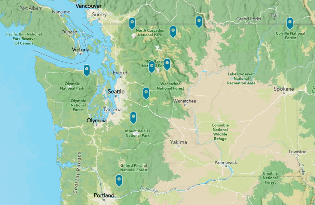
WTA created a report featuring 10 forest roads in Washington state that serve as critical connectors to the outdoors. Information came from WTA trip reporters, WTA’s trail maintenance staff, partners at five national forests and 1,271 hikers that participated in an August 2024 public survey. You can learn more about the 10 roads below and also in our interactive map and full report.
 Click on the image above for an interactive map locating the 10 roads in WTA's report.
Not only are these roads important individually, together they show how chronic underfunding of forest roads is restricting public access to areas of our state’s national forests. WTA advocates for continued investments on our public lands, including maintaining forest roads that hikers use to access trails.
Cayada Creek Road/Forest Road 7810
Carbon River/Mowich, Mount Rainier Area
“Worst road leading to one of the best hikes.”
Photo by WTA trip reporter youcandoit
Cayada Creek Road, which leads to Summit Lake trailhead, was the road most cited by hikers in WTA’s August 2024 statewide survey on forest roads in need of maintenance.
Deadhorse Creek Road/Forest Road 37
Mount Baker Area, North Cascades
Recovering a road, and summertime paradise, after years of closure.
Photo by WTA trip reporter Grudis
In 2021, a flood washed out Deadhorse Creek Road 9.6 miles before the Skyline Divide trailhead, putting this trail and its panoramic mountain views out of reach for all but the most intrepid hikers.
Forest Road 5600: Middle Fork to Dingford
North Bend Area, Snoqualmie Region
Increasing opportunities in an outdoor recreation hotspot.
Photo by WTA trip reporter jrap
Addressing maintenance needs on this road would increase access to trails in one of the most visited areas in Washington for outdoor recreation.
Sloan Creek Road/Forest Road 49
Mountain Loop Highway, North Cascades
Bringing wilderness within reach, for hikers and trail crews.
Photo by WTA trip reporter The Warder
This road provides access to six different trailheads, including entry points to the Glacier Peak and Henry M. Jackson wilderness areas.
Silver Star Road/Forest Road 4109
Lewis River Region, Southwest Washington
Regaining an outdoor experience for all ages and physical abilities.
Photo by Cheryl Hill
Forest Road 4109 is undriveable, even for most high-clearance vehicles. Mountain views of Rainier, Hood and St. Helens, wildflowers and wildlife sightings start at the trailhead’s parking area. These outdoor experiences that would be available to people of all ages and physical abilities — if they could navigate the road.
Forest Road 2875 to Slab Camp Creek
Hood Canal, Olympic Peninsula
From eyesore to entry point into nature.
Photo courtesy U.S. Forest Service
Hikers, including families and those newer to outdoor recreation, encounter a heavily-potholed road that has become a hotspot for illegal dumping on their way to this classic river hike in the Olympics.
Chiwawa River Road/Forest Road 6200
Stevens Pass – East, Central Cascades
Gateway to a host of outdoor treasures.
Photo courtesy U.S. Forest Service
Maintenance on Chiwawa River Road would lower the barriers to reaching one of the most beautiful areas in Washington — with opportunities for day hikes, multi-day backpacks and thru-hikes from Glacier Peak Wilderness to Lake Chelan — to a whole segment of the population that doesn’t own a high clearance vehicle.
Hart’s Pass Road/Forest Road 54
North Cascades Highway, North Cascades
A unique outdoor experience for all physical abilities.
Photo courtesy U.S. Forest Service
The Hart’s Pass Road is the highest elevation road you can drive to in Washington state and the primary access point for the Pacific Crest National Scenic Trail. It provides a unique experience for visitors of all physical abilities but it is in constant risk of closure due to erosion.
Forest Road 39 to Iron Gate
Pasayten, North Cascades
A backpacker’s dream destination threatened by road conditions.
Photo by WTA trip reporter Kris B
This road is a primary access point for the eastern section of the Pasayten Wilderness, the largest wilderness area in Washington state, and the Boundary Trail that spans that wilderness area.
Forest Road 245 to Sullivan Mountain
Selkirk Range, Eastern Washington
Limiting recreation, stewardship and emergency response.
Photo courtesy U.S. Forest Service
This is the only road providing access to Crowell Ridge that is open all summer, making it critical for recreation, trail maintenance and emergency response for the area’s system of trails.
 Washington Trails
Association
 Click on the image above for an interactive map locating the 10 roads in WTA's report.