
Wow, what a wildflower hike with great views too! Route: the Silver Creek trail up to Bear Gap on the PCT, 1.5 miles south on the PCT, (turned around) 4.5 miles north on the PCT, and down the Bullion Basin trail, 10.5 miles.
There are lots of flowers on almost all of the 4.5 miles on the PCT. The Bullion Basin trail and upper portion of Silver Creek are flowery too. This portion of the PCT sticks to ridges and winds around peaks with ever changing aspects and views. This leads to a huge variety of flowers. Two years ago I led a Mountaineers hike here, there were 2 naturalists on the hike and they identified 75 flowers. There might be that many right now. The attached google photo album has lots of photos showing the volume of flowers (with the views in the background) and some individual flowers.
I've attached a color-coded Caltopo map of the route with flower information and areas of special interest. The green indicates sections of really good flowers. The orange is the one section on the PCT where there aren't a lot of flowers. The black sections are forested areas with few flowers.
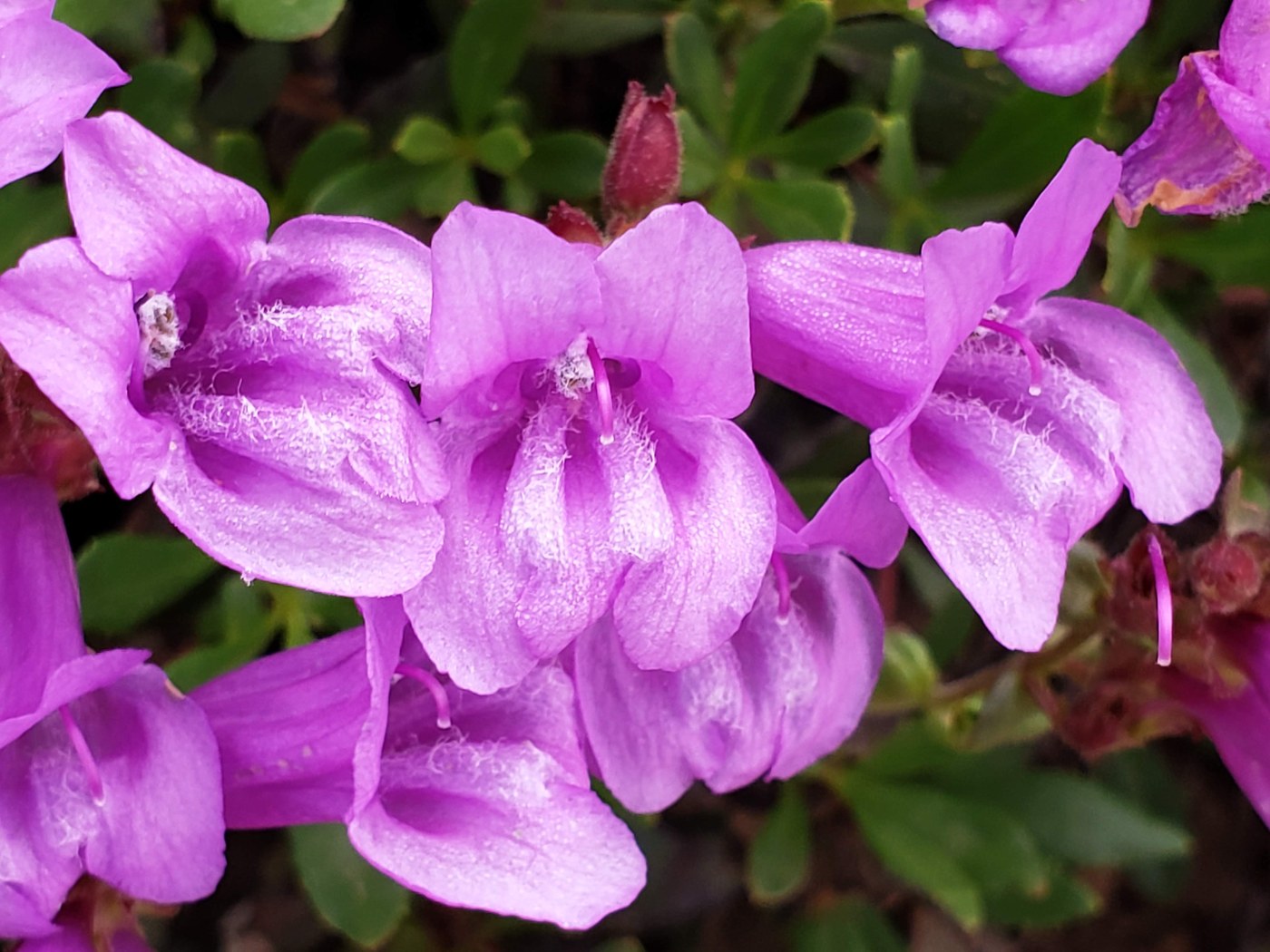
The purple section is the .5 mile south of Bear Gap. It has the brilliant turquoise rock penstemon (the cover picture) and at least 2 other species of penstemon. There are lots of Tiger Lilies and some the red paintbrush is beautifully fading to orange. Picture 2 is from this section.
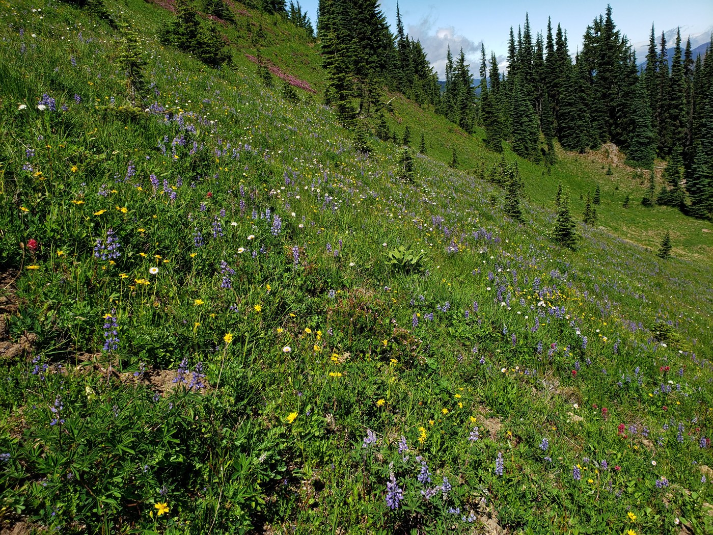
The yellow section (picture 3) is at the southern end of the route. It melted out fairly recently. There are lots of yellow flowers: western wallflowers, arnica, snow buttercups, and cinquefoil, with red columbine, purple speedwell, blue Jacob's ladder, and others thrown in for variety. At the end of this section where the trail turns to the south (right), there is a thick patch of Rainier lousewort that is just starting to bloom with its bright yellow spirals.
The red section (picture 4) is the large meadow that is between the 2 trails that lead down to Bullion Basin. The pink mountain heather patches are brilliant here and will be getting even better. There is a lot of magenta paintbrush blooming and more to come. There is a lot of lupine, part of the hillside below the trail is painted blue with lupine.
This trail is always amazingly uncrowded. I started "late", 6:00 AM, on this (eventually) sunny Wednesday and I didn't see anyone for 4 hours. In the 7 hours I hiked, I saw 5 people in 4 groups. It was always easy to find some distance, I had to backtrack 50 feet or so twice to find a spot. Car counts on the drive home in the 1:00 PM hour, Norse Peak-15, Ranger Creek-2, Dalles Creek-1.


Comments
Chasingsunsets on Silver Creek, Pacific Crest Trail (PCT) - Chinook Pass to Snoqualmie Pass, Bullion Basin, Pickhandle Gap Loop
Thanks for the flower reports and all the great info. Love the pics and especially the color coded map! In the purple section of your map, how much ridge exposure is there in that .5 mile section of the PCT? I have some issues with heights so I don't love trail sections with big drop-offs, especially when I'm hiking solo, but those flowers looked amazing!
Posted by:
Chasingsunsets on Jul 23, 2020 09:52 AM
AlpsDayTripper on Silver Creek, Pacific Crest Trail (PCT) - Chinook Pass to Snoqualmie Pass, Bullion Basin, Pickhandle Gap Loop
You're welcome. I am pretty sensitive to exposure. There are sections of the Kendall Katwalk trail that make me nervous. None of the 4.5 miles on the PCT is as bad as those parts of the Katwalk trail, none is as bad as Burroughs Mt. (Frozen Lake to 1st Burroughs), and none is as bad as the Sunrise Rim way to First Burroughs. I can't think of any parts of the purple section that are exposed. There are a couple of places south of the purple that have a little exposure, but nowhere would you fall to your death or serious injury. The slope is at most 40 degrees and mostly has vegetation on it. If you tripped and went over the side, you would stop within a foot or two. If there is a trail that makes you nervous or stop, let me know what it is and if I am familiar with it I can compare it to this trail.
Posted by:
AlpsDayTripper on Jul 23, 2020 02:49 PM
Chasingsunsets on Silver Creek, Pacific Crest Trail (PCT) - Chinook Pass to Snoqualmie Pass, Bullion Basin, Pickhandle Gap Loop
Thanks so much for the quick reply and helpful info! The last trail I had to stop was Heather-Maple Pass loop - coming up counterclockwise, past Heather Pass and the big viewpoint area where you get up and are looking straight down at Lake Ann. I ended up turning around there because I started to get vertigo. (And in the photos you posted, the last photo on the bottom right, I know that would make me too nervous.) A lot of times it's just my brain perceiving something as much scarier than it actually is, but I'm a cautious hiker so I try to avoid getting into situations where I might start getting dizzy when I'm by myself. Thanks again for the info, it's much appreciated.
Posted by:
Chasingsunsets on Jul 23, 2020 03:58 PM
AlpsDayTripper on Silver Creek, Pacific Crest Trail (PCT) - Chinook Pass to Snoqualmie Pass, Bullion Basin, Pickhandle Gap Loop
I understand, I've had it where my body won't listen to my commands. There's evidence that genetics influences whether we have a fear of heights, I never feel bad about it. From the info you gave, I think you'll be OK on the purple section. You might not like the spots south of there I mentioned. Thanks for asking. Have fun!
Posted by:
AlpsDayTripper on Jul 23, 2020 06:15 PM