WTA trip report technology: Disappointing that trip reports won't sync from the mobile app, and I can't seem to add photos inline through the website in Firefox.
First of all, thank you to the friendly local rangers in Chelan for as much information as you had about the condition. As promised, here is a report.
Road
There is a reason Summer Blossom doesn't seem to be a popular access point to the Sawtooths - it's a VERY long access road. We took Grade Creek Road via Atilon Lake as recommended by the ranger station. Google won't route you up Grade Creek Road this way, but it's open. The road was in reasonable shape up until South Navarre Campground where it is in terrible shape and we barely made it in a Toyota Camry (it was dicey). Even with the lower section being in a state of good repair (minus occasional rock fall) it's very slow going. Measuring about 25 miles long it took us an hour and a half going up and two hours going down (so as not to let our momentum carry us over the ever present edge). The road has scenic views over the lake, and would be a fun place to mountain bike. The other way to access the trailhead (that Google tires to send you on) is in worse shape apparently as we met a couple of guys in a Jeep who said they were only about to do about 15 MPH the entire way (we were able to do 20 MPH on the way up in a Camry by comparison).
Maps
We used Green Trails and the USGS topo layer in Gaia GPS. The default Gaia GPS layer seems to be missing a number of key trails in the area for no apparent reason. The USGS tended to be optimistic about the presence of trails, Green Trails a bit pessimistic, and Gaia GPS just incomplete.
Trails
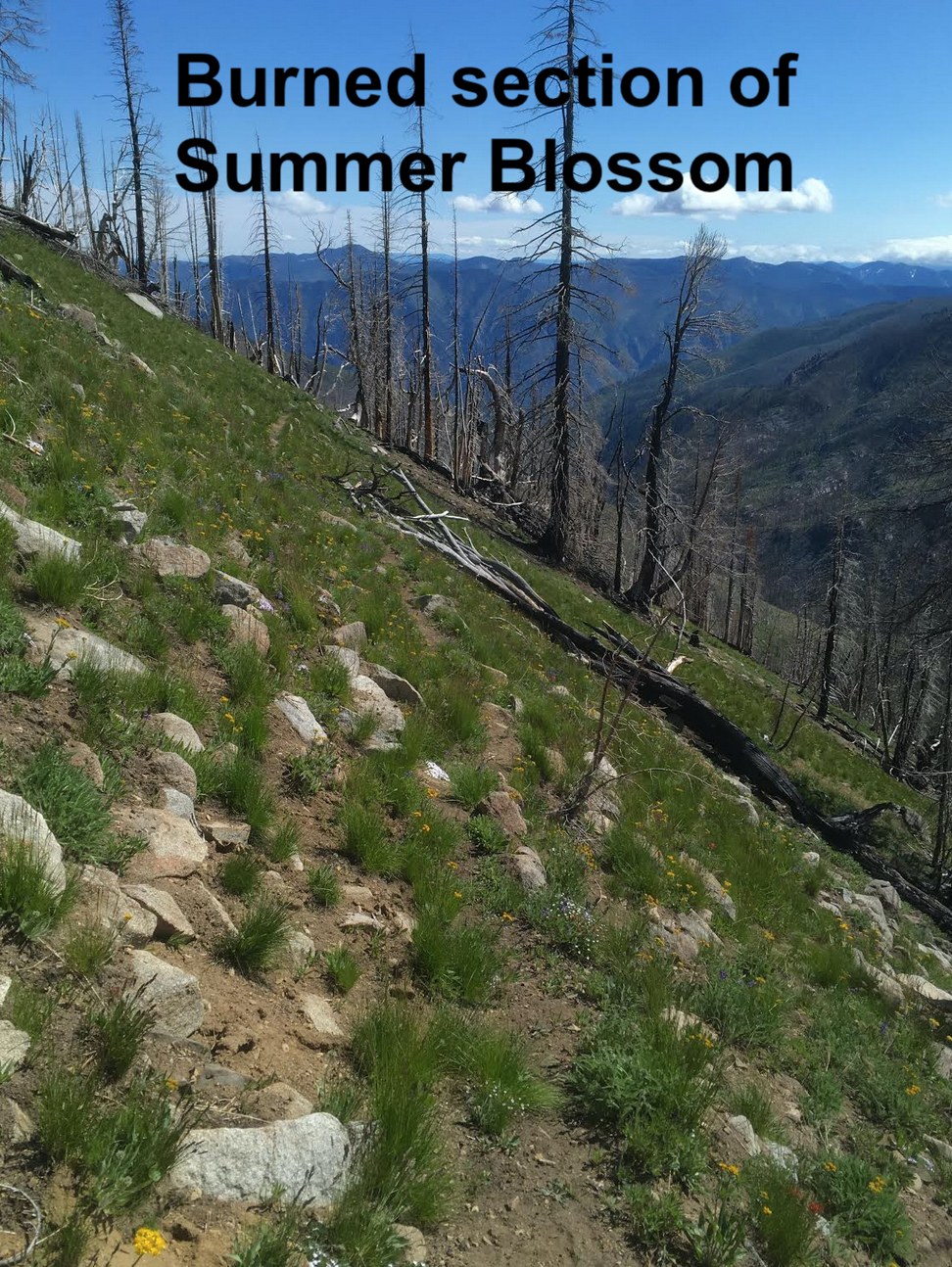
Summer Blossom Trail: The trail starts high and stays high resulting in great views the entire length. Despite what it looks like on the topo, there is some significant up and down along the way, including right after the trailhead where you climb over North Navarre Peak (on some impressive legacy CCC rockwork trails). Sadly, at some point most of the valley below (Safety Harbor area) burned and that fire also caught some of the forest along this trail. The trail itself is slowly fading away into the meadows and eroding slopes, but still fairly easy to follow for the most part. There was water before North Navarre and again in a meadow at 48.1534, -120.3597, but otherwise it's pretty dry. I imagine the question you're probably asking yourself is whether it's worth it to access the Sawtooths from Summer Blossom. On the one hand, it's a high lonesome ridge with rewarding views. On the other hand, the access road adds a lot of time, the burned section is sad to look at, and the exposure would make it very hot mid-summer.
424: out of curiosity I went to see if 424 could be found from the ridge, but I couldn't find a trace of it.
417B: The old trail over to Sunrise Lake from Summer Blossom (shown on USGS but no Green Trails) is steep but easy enough to follow to the saddle. From the saddle down however the old trail completely dissapears into erosion and steep snow fields. It's a submlime approach to the lake, and hopefully can be restored sometime.
Camp - Sunrise Lake: There was lots' of snow remaining around the lake (and it snowed on us the next morning), but one of the campsites was thawed out (as was the lake itself).
417 Angel's Staircase: It was cloudy and windy the next morning as we ascended Angel's Staircase, but even so the alpine meadows were pleasant and the few views we did get very rewarding. Looking down the trail towards Cooney Lake, there was a lot of snow still, but probably doable later in the day when the snow gets soft if you feel comfortable with snow travel.
1259 to Middle Fork Prince Creek: felt like the first section of trail maintained to common widths and standards although evidence of motor bikes seems to be rutting out parts of it.
1259 to Chimpmunk Pass: This was a delightful surprise. The trail reverts to less maintained state seemingly common in the southern Sawtooths, but still easy to follow. But the views were gorgeous and you quickly break through the treeline and traverse around a ridge with views down to Cub Lake and beyond.
1259 to Prince Creek: Some pretty meadows early on just after Chipmunk, and then a pretty standard walk along a river. A number of blow downs in this section, but all are manageable on foot (not sure about horses though).
Camp - Prince Creek Valley: Both the USGS and Green Trails seem to think the campsite is earlier than it actually is. There is an Appalachian Trail style open shelter here with a toilet. The camping was sheltered from the chilly wind we had been experiencing higher up and there are some nice meadows nearby. If we were to do this trail again, I don't think we would stay here unless the weather was particularly nasty, given other nicer campsites in the area.
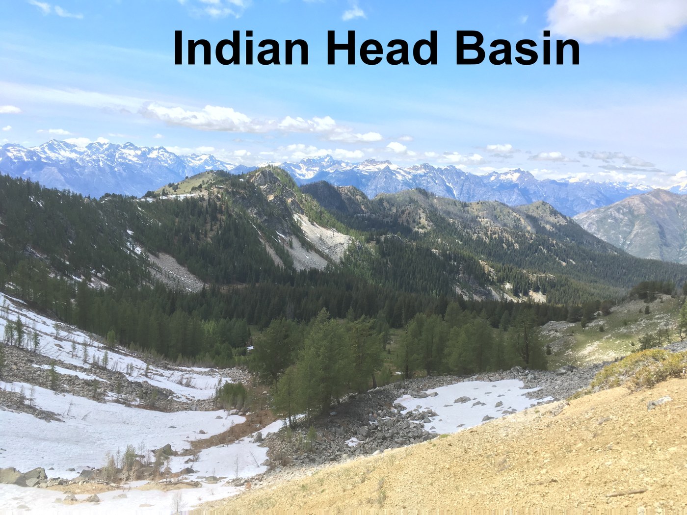
Day hike to Indian Head Basin: Beautiful views and meadows on the way up. The arm above Surprise Lake and the pass above Indian Head were highlights of the trip. We went down into Indian Head Basin where just after the wetland we found an old trail Forest Service Trail 1250.2 – Cascade Camp Trail, that doesn't appear on any maps I've been able to find other than this USFS recreation map https://www.fs.usda.gov/recarea/okawen/recarea/?recid=57149, that takes you to the saddle SW of the basin. The saddle has views out to Glacier Peak Wilderness areas. I'd love to know the history of 1250.2 and where it goes (it seems to dead end into the high meadow).
Hike out: After a second night in Prince Creek Valley we marched back to Summer Blossom Trail head diverting from our original path only to use Dead Man's Pass rather than goings through Angel's Staircase/Sunrise Lake. Dead Man's still had quite a bit of snow on the north side, which made the steep climb challenging.
Overall, it was a glorious trip filled with solitude and sublime vista, charming meadows, and babbling streams (there was a lot of water available for the most part). The weather was cold and windy, but this seemed to keep the bugs at bay so a trade worth taking.
Trip Report
Summer Blossom, Sunrise Lake, Angel Staircase, Prince Creek, Chelan Summit & Indian Head Basin — Saturday, Jun. 27, 2020
 North Cascades > Methow/Sawtooth
Type of Hike
Multi-night backpackTrail Conditions
Obstacles on trail:Overgrown in places,
Mud/Rock slide or washout.
Road
Road recommended for high clearance onlyBugs
Bugs were not too badSnow
Snowfields to cross - could be difficult

Comments